This blog is linked to the Goldsmiths, University of London History module, ‘Walking Through London’s History’.
Posts made on this blog have been produced by students taking the module as part of their formative and summative coursework.
Please feel free to comment (constructively) upon these posts as responding to comments is part of the learning process.
For students posting on this blog: This blog is in the public domain and your posts will be publicly available, so please keep that in mind when creating content. Make sure you reference your sources and any images that you use.
East London, specifically the Whitechapel district during the 1880s, suffered from high levels of poverty and crime leaving it to be the perfect location for the Whitechapel murders of 1888. These murders were also known as the Jack the Ripper murders. This case was the first of its kind to reach the scale of international frenzy and interest in the case is continuously increasing. Even to this day the identity of the Ripper remains unknown.
Knowing that the Ripper has been dead for a very long time the stops for my walk will be the first three murders of this unsolved mystery. My walk begins at the site of the first murder, Durward Street (used to be Buck’s Row), where the body of Mary Nichols was found. Facing west, I notice the Durward Street Board School amidst the Crossrail constructions. This building would have been there at the time of the murder but looking slightly different than now. Durward Street has changed subsequently over the past 100 years, firstly the change of name is quite obviously one reason. Where there used to be a line of cottages are now a line of modern houses. In between the school and modern houses would have been the spot where Nichols body was found. At this time, during my walk the street is empty, much like the night of Nichols murder, except for construction workers who stand at the site entrance. However, behind the building and the construction works is Whitechapel Station where it is bustling with people.
Turning away from Durward Street I make my way through Brady Street and then left into Whitechapel Market towards the second murder site. Walking through the market brings a different ambience to the one I felt at Durward Street where I was alone. During the late 1800s Whitechapel road was the site of the Whitechapel Hay market. Across the road from the market lays the old Royal London Hospital building which bares empty whilst the new hospital building behind is full of patients, doctors, and families, etc. Furthering on west I reach the end of the market and the beginning of Vallance Road where I turn right into. Just a little into Vallance Road I turn left into a walkway which leads me unto Hanbury Street.
At this end of Hanbury Street there is the Brady Arts & Community Centre. Further along is another building called the Montefiore Centre. This building started off as a school built by Robert Montefiore and has since gone through many name changes since. In 2007, it was renamed back to Montefiore and is a centre for many educational organisations and training. As I walk on west towards Brick Lane, I observe how contrary the atmosphere felt to that of Whitechapel market. Just before I reach Brick Lane, I notice the Bangla Town cash and carry and nearby a man spray painting something “artsy” on the walls. That must happen a lot around here since the last time I came here there was an Antman and The Wasp painting covering the wall. Walking past I realise that I had no idea where the exact spot Annie Chapman’s body was found. All I know is that it was near Truman’s Brewery. During some time in the 1800s Truman’s Brewery was the “biggest brewery in the world”. Staring at my phone and trying to figure out where to go was exhausting me, so I prepare my way towards the third murder site at Henriques Street (used to be Berner Street).
I leisurely walk down Brick Lane towards Whitechapel High Street. As I walk through, I take heed of the Brick Lane mosque and Christ Church Primary School. When I make it to Whitechapel High Street, I subconsciously cross the road and make a shortcut through Altab Ali park into Adler Street. From Adler Street I come onto Commercial Road I cross the road again and make my way eastwards. Since I know my way around here the walk does not take me too long to reach my destination. Not far from the crossing is Henriques Street. This is the place of my last stop but not the last of Jack the Ripper’s murders.
Berner Street was renamed to Henriques Street after Basil Henriques, OBE (1948). During the 1880s, the street was known to be respected as it was inhabited by dock labourers, carmen, shoemakers, and tailors. The murder of Elizabeth Stride that took place on this street was at the entrance of Dutfield’s Yard. Although, Stride was one of the victims of the Ripper, her body was not mutilated like that of the others leading many to believe that the murder may have been interrupted. Dutfield Yard no longer exists but nearby is Basil House, perhaps also named after Basil Henriques. Slightly opposite Basil House is Harry Gosling Primary School built in 1910 and named after the Labour MP, Harry Gosling. With that this account of my walk ends.
References
“Jack the Ripper 1888.” Accessed December 23rd, 2019. jack-the-ripper.org.
As a study abroad student coming from Amherst Massachusetts, but internationally from Lahore, Pakistan with a dual citizenship also from Canada, I have always considered myself a flaneur. Being a 20 year old woman, and being a city girl at heart, exploring London as much as I physically could was divine, a dream. Not being used to the tubes, my go to app being the city mapper, I decided to head out like usual but this time alone, and in the morning. Living in the student accommodation on campus, one thing in my advantage was the tube which was opposite my dorm. This was the first time I left without any purpose in mind. I left at 12 pm, and walked towards New Cross gate station. This was a new city for me, and going out alone and not being a pro at the transportation did instil some sort of fear in me. Following my app, I waited for my train to ‘Highbury and Islington’ at platform five.
Not really having any destination in mind, I did know that I wanted to go central. The people waiting were early birders. Perhaps getting ready for office, commuting to the city for work, young mothers all with fresh faces that seemed like they had just gotten ready for the day. I did know that I was supposed to get off at Canada Water, and then take the jubilee line to central. From Canada Water, I got off, and I was glad to see that the station wasn’t crazy packed like it usually is. From Canada Water, I looked at the tube maps that they have on every train and in the moment made up my mind to get off after six stops at Green Park station. As I had some time, I started observing, also an old habit of mine wherever I go. Every city, every place puts me in awe, the people, their dressing, the way they speak, the accents all move in circles in my mind, yet here I was examining a whole new culture. I saw different people as a whole, but more diversity within those people with each other more. I started comparing it to the people I saw on my tube from New Cross gate to Canada Water. The diversity within just some time, some miles, made me think of their economic backgrounds, families, and jobs. People on my tube from Canada Water to Green Park were more modern, more dressed up, more touristy, while before they all seemed like locals who were tired and had to go to their jobs or drop their children off to school. I got off at Green Park, counting every stop and hoping within and telling myself again and again to not get lost. I decided to follow where the majority of people were going, and decided to take the Piccadilly line to Knightsbridge. I have been to London before many years ago but only lived central and so the names listed on the Piccadilly line sounded familiar which did put me at ease. The majority of the people were young, were louder, were more full of energy, and clearly seemed excited for where they were headed. It also got more crowded. I got off at Knightsbridge station, and saw Harvey Nichols. I instantly wanted to go in, and also got interested in finding out more about it – was it constructed a long time ago? Does it have any history?
Harvey Nichols
According to the Harvey Nichols website, the store opened in 1831 by a man named Benjamin Harvey. He had ‘opened a linen shop in a terraced house on the corner of Knightsbridge and Sloane Street in London’ (Harvey Nichols Group Limited, 2018). After four years however, the store expanded, and continued to until 1841, when Benjamin employed James Nichols who was from Oxfordshire. Nicholos promoted to management in 1848, and married Harvey’s niece, Anna Beale. During that same time, Benjamin Charles was born, Harvey’s son. Benjamin passed away in 1850, and left the business to Anne, his wife who then went into business with James Nichols to form Harvey Nichols & Co (Harvey Nichols Group Limited, 2018).
It also stated that during the time period 1975 to 1991, Harvey Nichols continued to expand as a restaurant also opened on the Fifth floor and was a huge success. During the 1980s, started expanding by diverse collections like Max Mara and other brands, and out of the six floors, four of them were dedicated to fashion. In 1985, Harvey Nichols was bought by the Burton Group, and in 1991 it was bought by Dickinson Poon, and he made many renovations. It gained more and more popularity by the day. After six more years, in 1996, Harvey Nichols was listed on the London Stock Exchange and in 2000, the first international store opened in Riyadh. Saudi Arabia. Now, Harvey Nichols has expanded so much to the point that it has opened seven stores within the United Kingdom along with stores in Ireland, and five large stores in London, Edinburgh, Birmingham, Leeds, Manchester, and two small ones in Bristol and Dublin, along with large international stores in Turkey, Riyadh, Dubai, Hong Kong, and Kuwait (Harvey Nichols Group Limited, 2018).
After I had examined mostly all the floors, and was mesmerized by the fashion and clothing, and after buying some makeup, I decided to head out. I kept on walking straight, and knew I was in the Knightsbridge area, but still managed to make a circle around Harvey Nichols admiring the window displays, and feeling a bit lost. I did not know where to go so I walked past the entrance again and kept on walking straight. I saw one of the gates to Hyde Park and decided to go in.
Picture taken by a stranger at Hyde Park -showing how I felt exactly. Thrilled, but also hesitant to explore the city further all by myself.
I got out of Hyde Park and walked towards the ‘Hyde Park Corner’ station which was next to the rose garden. I got on the Piccadilly line again and got off at Green Park.
Exit to Hyde Park gate.
I changed and from Green Park station I got off at Oxford Circus. I had been to Oxford street many times before, but being on one of the busiest streets and the most famous ones in London by myself with all the Christmas decorations on felt amazing. I had never realized the little things about it before. How there is Christopher’s place right behind this small street that I had never noticed before. New alleys, new eateries, and new shops. It all seemed different, as if it all started to make sense now.
Oxford Street
Everyone seemed busy in their own way. Christmas shopping, couples enjoying the lights, catching up with friends. It all seemed like a completely separate part, so disconnected from my New Cross area, but still all together connected. It made me think of how all these diverse areas are all considered under one city, London. I kept on walking straight towards the Marble Arch which I saw from afar. I knew this was one way to get into Hyde Park, and I had just been there just some hours ago. I passed the Marble Arch, and continued to walk straight until I felt a wave of home. I could see people dressed in shalwar kameez, talking in Urdu, so I saw Pakistanis, and lots and lots of Arabs. Where was I? I had not been on this road before. The restaurants were all mostly Lebanese. I could smell shawarmas, and the strong smell of ittar. It all made me happy. I wanted to know the name of the street, so I stopped by Salt, the first restaurant I could walk in without a queue ask someone inside. It was called Edgeware Road, and I had also asked about the nearest station. The waitor had told me to keep on going straight. It seemed like a really long walk, I passed by Forset Court, and the Hilton Hotel. I saw the Edgeware Road tube station, and decided to finally go back home. I took the Jubilee Line Southbound to Baker Street, and then then changed my platform to go to Canada Water, and two stops to New Cross gate. People on the tube seemed tired, with cranky children, and some were even making food delivery orders.
My journey and these three destinations made me personally feel the notions and emotions of the city, the differences in attitude of people, and it helped me develop more curiosity and love for this city.
London’s rich history left me struggling to choose a walk which would be unique, while still providing nod to the famous walkers of the past and provide material for the historian in me to tease out. Instead of pursuing an impossible perfection I started on a whim coming up with my walks two rules at the southern entrance to the Greenwich Foot Tunnel. The idea was simple, walk along the Thames and cross the river at every opportunity, hoping to let the walk do the work.
Symbolism of the Bridge
Before I’d even made it halfway through the tunnel I started to deconstruct the choice I had made, realising quickly that bridges had featured prominently in all sorts of music, film and poetry throughout my life. It is easy to imagine why bridges and tunnels as objects lend themselves so easily to symbolism with one of the most well-known examples being William Wordsworth’s ‘Composed upon Westminster Bridge, September 3, 1802’.
Earth has not anything to show more fair:
Dull would he be of soul who could pass by
A sight so touching in its majesty:
This City now doth, like a garment, wear
The beauty of the morning; silent, bare,
Ships, towers, domes, theatres, and temples lie
Open unto the fields, and to the sky;
All bright and glittering in the smokeless air.
Never did sun more beautifully steep
In his first splendour, valley, rock, or hill;
Ne’er saw I, never felt, a calm so deep!
The river glideth at his own sweet will:
Dear God! the very houses seem asleep;
And all that mighty heart is lying still!
Even Wordsworth known for his poems romanticising the English countryside finds himself overcome by emotion when crossing the bridge and immediately attempts to give the reader a glimpse of this. The poem has also been said to capture London at a time of social change at the height of the industrial revolution.
As well as possessing the ability to excite the imagination London’s river crossing display the remarkable engineering feats that are a mark of Victorian ingenuity. The Greenwich Foot Tunnel, though opened in 1902, was created to offer an alternative for the unreliable ferry crossing to the Isle of Dogs. In what could easily be the bowls of great steel ship you are thrown back in time and can really get a sense of what the crossing must have been like over 100 years ago.
Neglected history
Walking along the Thames sticking as best I can close to its bank I begin to notice the remnants of a trail which pays tribute to towards the history of the docklands. It’s neglect is possibly a reflection of the rapid progress which is evident right across the city if one is careful enough to look. J.G. Ballard might have enjoyed the suburban feel of the Isle of Dogs never ending river side apartment buildings. The lives of the residents must surely be more interesting than the plain facades of the buildings. As Ballard supposed are they emotionally disassociated from this landscape left waiting for it to be filtered through popular culture? In any case, rather than attempting to delve further into such a heavy topic, I find myself searching for signs of the peninsulas maritime past.
The most obvious sign is actually the lack of signs that show the history of the docklands. Rather than leave a unique mark on the area its past is used more as a subtle aesthetic choice for architecture and an easy reference for street names. I do however stumble on the seemingly forgotten ‘Docklands Heritage Trail’. As you can see from the pictures the information boards have been severely weathered and even though it forms part of the ‘Thames Path’ it is hard to imagine a member of the public gaining any significant insight into London’s past. This far off the tourist path amongst the densely populated residential suburbs is the poor attempt to remember the past even the appropriate way to reach anyone who would seek it out?
Tower Bridge
I finally arrive at the next crossing, Tower Bridge, with such a radical change in atmosphere it feels as if I have entered ‘proper’ London. Just as with The Greenwich Tunnel, Tower Bridge is an engineering creation from the Victoria era but it is more than another example of impressive mechanical engineering. The bridges facade that serves as decoration could be argued to be part of the self aware attempts of the Victorians to embellish the identity of the Nation. Its gothic style paired with that of The Palace of Westminster gives it an feel of being much older than its construction.
As you can see from the photos and hear from this soundscape the bridge is buzzing with activity.
London Bridge
Amongst the tourist gridlock across Tower Bridge it is perhaps understandable why I failed to notice the anti-vehicle measures installed on London’s bridges after the Terror attacks of 2017. The potency of choosing London’s bridges perhaps goes beyond their place in the centre of Britain’s capital city but as a symbol of something which forms part of western identity, perhaps only subconsciously, the perpetrators of the attacks took aim at.
The information boards in the city are obviously well maintained and just like the bridges gothic facade they form an important part of a potential visitors
Southwark Bridge, Millennium Bridge and Waterloo Bridge
While the Millennium Bridge would prove to be the most beautiful crossing Southwark Bridge would turn out to be the least interesting crossing of the day closed off from traffic as a result of protests in the capital first by environmentalist, then by taxi drivers. With this in mind and far from the romantic scenes which inspired this walk an empty Southwark bridge affords me the time to examine the inspiration for this walk once again. From the beginning I’ve tried to think about how myself and the people around me are interacting with the urban environment.
Could walking be a way to incorporate the relatively new field, by academic standards, of the History of Emotions? The methods of historical study that involve immersing oneself in the sources could surely be enhanced by trying to imagine how the environment that these long passed people lived. One of the propositions of this type of history is that human emotions has been modified over time by the capitalist system that we live in.
See the introduction of Jan Plamper’s seminal text for a deeper insight into this field.
Journey’s End
The attempt to understand and actually create something which could fit within the world of psychogeography for me proved a challenge which I don’t think I fully bested. Walking definitely has the ability to enrich as well as inform and for me perfectly demonstrated the rapid and continual change that London goes through. From centre of an Empire to world financial centre with all the tropes which come along with being a modern city. Despite this I can only see walking as a jumping off point rather than be the entirety of a potential historical inquiry.
My walk is a rough circle around my home, it therefore brings together familiar and favourite routes I’ve been walking for several years. The shape of my outing is inspired by Iain Sinclair’s orbital walk of the M25, and though my own does lack the same the clarity of path, I am hoping to emulate him somewhat in interacting with the city, talking to people and thinking about historical contexts whilst observing the modernisation of things. To give my walk a little bit of a theme I have decided to focus on 19th and early 20th century public buildings, for example, bath houses, libraries, almshouses and schools, to see what remains of them, or what they have since become.
I begin in Burgess park, it’s early afternoon and the sky is threatening, I cross the pond and leave the park through the Albany Road exit, I walk down Old Kent Road. My first destination is planned and likely to be underwhelming; I want to reach the junction with Marlborough Grove, which is the site of the 1905 Wellington Baths, on my way I pass the Surrey Linear Canal park, named as it is built on part of the site of the early 19th century Grand Surrey Canal. Upon arrival I see, as anticipated, the bath house itself is gone, destroyed by a bomb in WW2, there is nothing i can find on the remaining site to mark it’s past presence now, just a block of flats.
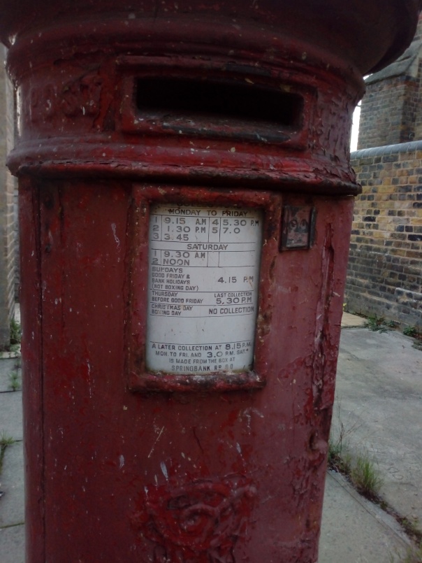
I keep walking down the Old Kent Road until I pass a red brick building, engraved in stone on it’s side it tells me it is (was) a public library erected in 1890 and, I am told by a blue plaque, given to the people by Sir George Livesey. I later read that Livesey’s gift of this library galvanised Camberwell Vestry’s adopting of the Public Libraries Act. Whilst I am in the small front garden taking photos and trying to peer in I am approached by and converse with a young man, he tells me the building is now an ESN school for children with autism, i apologise for my intrusion but he doesn’t seem to mind, and tells me that if i’m able to wait half an hour for the children to go home he’d be happy to show me around, as it has a very interesting interior. So I go for a coffee. When i return he takes me through to the garden, there are ruins from WW2 bombing, a statue of Livesy, and in a fenced off area as it isn’t structurally safe, an old shop front predating the library to 1805! One of the teachers tells me it’s part of the old street that would have been accessible here 200 years ago, and that it was noosemaking shop. Later i search for the name and date and find a possible advert for the business with the same establishment date. Another point of interest although not one I can be historically specific about is an (obviously) out of use red post box, with a clearly archaic timetable insert.
I carry on my journey, and turn onto my favourite road, Asylum Road, the first destination I meet is Caroline Gardens, a cluster of houses which I have noticed before but don’t know anything about, I enter and speak to man walking his many dogs, who tells me it’s mostly council owned, and directs me through an alley to look at the great hall. Caroline Gardens was built 1827 by the Friendly Society of Licensed Victuallers, and is the largest surviving Almshouse in London, as it is not just one building, but a beautiful housing complex. Though named an “asylum” it didn’t house the mentally unwell, but was a final home for elderly and/or infirm pub landlords or alcohol sellers and their families, giving them a life of “humble but respectable retirement”.
Asylum Road turns on to Queens Road, which becomes Peckham High Street, which becomes Peckham Road, all in less than a mile. Camberwell once had many factories, and so I pass the old sausage factory, now home to hermit artist Raqib Shaw, and the old piano factory. Peckham Road becomes Camberwell Church street, and I shortly thereafter arrive at what is now Camberwell Leisure Center, previously Camberwell Public Baths & Wash Houses. Erected in 1891 it is part of a trio with Dulwich Baths and the long gone Wellington Baths I visited earlier, all built by the Vestry of Camberwell in adherence to the Bath and Wash-houses Act of 1846, which was a product of the Royal Commission into the Sanitary State of Large Towns and Populous Districts, hence why the facilities were not built until after the area became overcrowded in the 1870s. They existed so that people could clean themselves and wash their clothes in order to hopefully stop the spread of disease, access to either the first or the class pool depended on rates one payed. Men and women had separate pools in Camberwell, Whereas on Old Kent Road they used the facilities on alternate days.
I double back on myself for a minute, then turn left onto Vicarage Grove, right onto Brunswick park, left onto St Giles Road, turn right onto Ada road, left onto Havil Street which intersects Southampton Way and becomes Wells Way. We’re back in the park. I’ve saved a building I find particularly interesting for last. It is the Passmore Edwards Library and Washhouse, funded largely by the philanthropist it is named after, rather than the local vestry, as with the other two wash houses. It’s lovely to look at, with interesting sculptural details typical of the newly Edwardian period. On the side of the building is a large tiling of the butterfly variety Camberwell Beauty, named for two specimens found on Coldharbour Lane in 1748. The mural was moved here in 1982 from the stationary company it is an emblem for. The bath house and library is now home to Londons oldest amateur boxing gym. I like this building because it is a “one stop shop”, an interesting combination of two aspects of public life, one practical and the other educational.
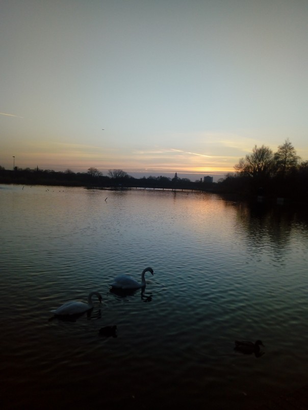
I have now come full circle, and am finishing my walk in the park at sunset. To breifly conclude I would say I have enjoyed making connections between the buildings I’ve visited today, seeing who they were funded by, what they were used for then and are used for now. I’ve also had quite success in talking to people I’ve met, and learning through oral history.
My Sunday morning walk, from Hanbury Street to Columbia Road Market
Markets are the lifeblood of any community, often reflecting the dominant culture of an area, and the needs of a community. The East End of London, with its vicinity to the docks, has welcomed immigrants and refugees from all over the world, and the area is defined by the varied cultures and communities that have inhabited it.
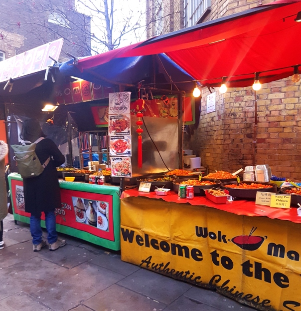
Brick Lane Market
The ever-changing art work dotted around the Lane is a huge draw for tourists and locals alike
My walk begins on a surprisingly bright Sunday morning. Brick Lane is the first market I intend to visit, and as I make my way down Hanbury Street, one of the many streets intersecting the lane, I notice an uptick in tourists. Brick Lane has garnered quite the reputation in the last decade or so, as the spot for some the best Indian restaurants in the UK, as well as the home of young creatives, and a thriving vintage market. Graffitied artwork adorns the bare brick walls, and photographers line up to take shots of well-dressed young people against the gritty background. I step towards the main thoroughfare and I’m immediately struck by the sheer amount of people walking around.
Truman’s brewery, still a part of East London culture
Above there’s a bridge, with Truman in golden lettering glittering in the sunlight. Truman’s brewery was once one of the largest breweries in the world, and pubs all over the East End proudly bare signs that Truman’s is served within. I continue, walking under the bridge and almost collide into someone taking photographs, something that is exacerbated by the large numbers of people and the unique aesthetic of the Lane. Despite the griminess of the area, people flock to it, and new shops are constantly opening to cater to the large number of visitors. A chocolate shop stands on one end, a ukulele shop on the other and in between, a collection of food stalls, with food from across the world at prices that make me flinch.
Food from across the world waiting to be savoured
Gentrification is a word often bandied about when talking about the East End and its effects are obvious to see, with more diverse options, but also much higher prices. It’s easy to see why some are so fiercely opposed to gentrification, but I’d argue that it breathes new life into areas that are often overlooked.
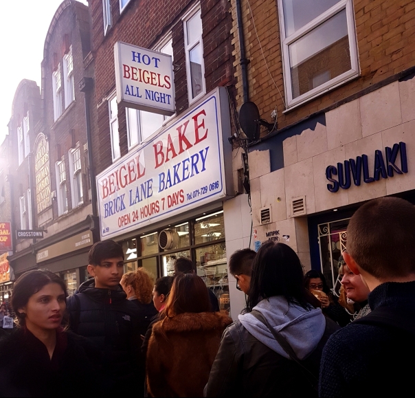
As I near the end of Brick Lane, two shops stand out, largely due to the queues outside. The Beigel Shop and Beigel Bake are neighbours, specialising in the same thing; bagels, and there are a multitude of articles that can be found online, furiously debating which is superior. These shops hark back to the days when the East End had a large Jewish population, who had fled the pogroms of eastern Europe, and it’s a curious sight these days, after passing by so many Indian restaurants to see evidence of a once thriving community that has largely vanished. It’s no surprise that it’s the restaurants that survive; food has the uncanny ability of uniting people and can help trace divergent histories unique to a place.
Long queues outside of Beigal Bake
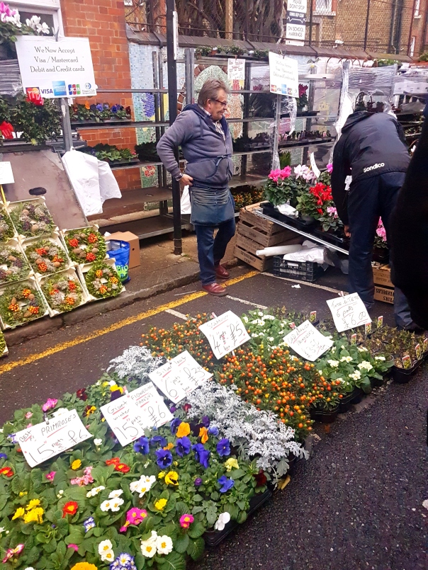
Columbia Flower Road Market
Once again, caught up in the crowd
I continue my journey, now heading towards Columbia Road Flower Market, another popular spot for both tourists and locals. An old market, it was founded at a point when east of the City was fairly rural, and in the 17th century the protestant Huguenots fled France and settled into the area, bringing their expertise with silk and love of flowers with them. I smell it before I see it, the scent of earth and flora, permeating the air through the city’s pollution and what a welcome scent it is. I turn the corner, and a packed street is before me, cobbled, with stalls on either side. It’s overwhelming, and vendors holler their prices, (‘Twenty roses for a fiver!’ strikes me as a particularly good deal), and I struggle to make my way down.
Christmas trees are all the rage at Columbia Road
Christmas trees seem to be the main attraction and I see them hefted onto people’s shoulders after purchase. Trade is brisk and despite it feeling like something of a tourist trap, there are a large number of locals milling about, bartering loudly with vendors who seem straight out of EastEnders. The market is filled with stalls, but brick and mortar shops also line the street, reminiscent of Covent Garden. Angela Burdett-Coutts, at one point England’s richest woman, funded the initial market, as well as the shops and flats above, hoping to create a success in an area so downtrodden. However, things didn’t go as planned, and the market was closed. It was an Act of Parliament that changed things, allowing for Sunday trading, taking into consideration the large Jewish population and their need to observe Sabbath on Saturdays. The market is now a staple in London, famous for its cheap prices and bright wares.
The flowers are hard to ignore at Columbia Road
I manage to finagle my way out of the dense crowd and make my way down another cobbled street, where a busker stands with a guitar, serenading passer-by’s. I stop for a moment, marvelling at how village-like the area seems, before heading off towards Victoria Park, a nice way to end a Sunday walk.
Busker croons as people walk by
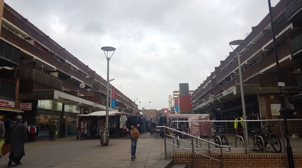
Whitechapel Market
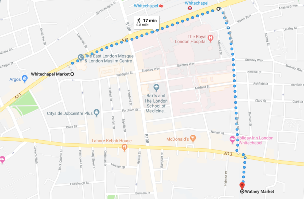
My walk from Whitechapel to Watney Market
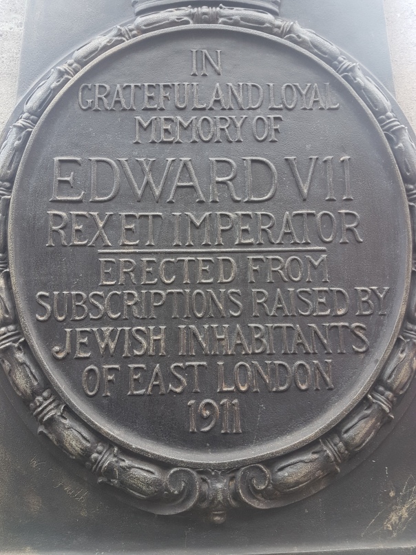
It’s the following day, and I undertake another walk, this time to less famed markets. I start off not too far from Brick Lane, a mere five minutes away, yet it couldn’t be more different. Whitechapel, known the world over for less than savoury reasons, largely the unsolved murders of Jack the Ripper. Yet at the turn of the last century, Whitechapel was a prominent hay market, in a period of time when horses were a vital part of London’s transport. Whitechapel has changed many times over the years, but there are hints of the past if you look closely. Hidden between two stalls stands an ornate drinking fountain and the plaque below states that it was built to memorialise the death of Kind Edward VII, and funded by the ‘Jewish inhabitants of East London, 1911’.
Plaque underneath the water fountain, dedicated to Kind Edward VII
These days, Whitechapel is more pedestrian, serving the local community with fresh produce and fish, as well as Islamic style clothing and food from South Asia. There are plans to rejuvenate the area, and there is no doubt that the area will change once more.
Fresh produce on offer at WhitechapelFabrics for as little as two quid, bargain!
My dalliance with Whitechapel market done, I head down Cavell Street, a much quieter, leafier area, largely residential. Named after a prominent nurse who served on the frontlines of the First World War, it’s dominated by the new Royal London Hospital, a gleaming blue block of buildings, a far cry from the older, more sedate building that used to house the hospital. Towards the end, traffic increases and I’m on Commercial Road, my last destination before me.
The new Royal London, towering over Cavell Street
Watney Market
Watney Market as it stands today
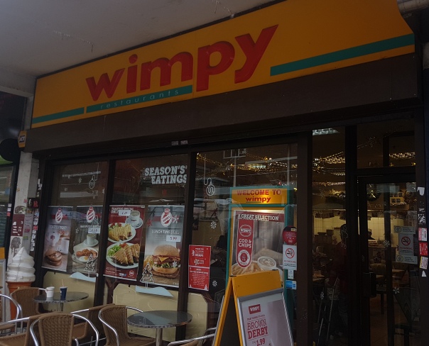
It’s a small market, one that isn’t well known, or as interesting as others in the local area, but has its own charm. It’s a frigid December morning and the stall owners are wrapped up well, shouting their offers to passer-by’s. Watney Market as it’s known sits a few minutes away from Shadwell station, between two brown council estates and serves as the main shopping district for the inhabitants of Shadwell. The long established Bangladeshi community have their stores, providing fish and spices imported from the motherland. Curiously enough, there’s also a Wimpy bar, a relic of yesteryear when fast food was still a novelty.
An odd sight in London these days, but still popular with the locals
There’s a charity shop, a hardware store and a fabrics shop. The range and variety of businesses within this relatively small area marks out how functional this market is and the clientele are largely the locals. The gleaming glass and steel of the much newer Idea Store towards the end of the market also highlights functionality over aesthetics, despite the modern design. It’s a library and a council ‘One Stop Shop’ rolled into one. The market feels a little rundown, but the Christmas lights stretching down the length of the place makes it cosy. Watney Market has been in existence for over a century and used to be one of the most popular markets in East London, boasting over 100 shops, including an early iteration of Sainsbury’s, now of course, one of the largest supermarkets in the UK. However, in the 1960s, a new plan was introduced, to completely demolish the market and build modern homes, as well as a new marketplace. The market was then again torn down in the 1990s, and low-rise homes were built instead, as well as space for stalls. Watney Market has seen much change in the last 60 years or so, but stubbornly refuses to die. Perhaps that’s the beauty of marketplaces; their refusal to be completely disappear. My walk has allowed me to appreciate the long history of the area, in particular the markets and how they are very much shaped by the communities surrounding it, providing an invaluable insight into what makes the East End so unique.
All images taken by the author.
Bibliography: All accessed and checked on 13/12/18
Virginia Woolf said: “As we step out of the house on a fine evening between four and six we shed the self our friends know us by and become part of that vast republican army of anonymous trampers” so, at 4:20pm on a cold winter’s evening I find myself outside 22 Hyde Park Gate, Woolf’s childhood home. Staring at the huge house, I wonder what it was like to grow up here. History is here, blue plaques are all along this street, a quiet little cul de sac compared to the roaring life of the main road it leads from.
This slideshow requires JavaScript.
I intend to follow several walks associated with Woolf meshed into one. I have been inspired by Anna Davin’s Standing on Virginia Woolf’s Doorstep, in which she writes about the importance of serendipity when walking in London (Davin, 1991, p. 74-75). I’m blending the walk Woolf made often as a child, from her house to Kensington Gardens (as described by this Radio 4 programme) with Street Haunting: A London Adventure and Oxford Street Tide. Rather than following these routes exactly, I’m drawing inspiration from them while trying to see London as a flaneuse. My plan is to walk from 22 Hyde Park Gate, through the park, and along Oxford Street.
It’s a relatively mild evening, although dark already. I walk up Hyde Park Gate trying to imagine growing up somewhere so grand, and marvelling at how quiet it is here. I notice the road sign, it has a sticker on it that I initially think says voyeur, so I take a picture, when I get home, I realise it actually says voyder. I try to find out what it means, all I find a website and a bunch of articles about a graffiti artist.
I turn left, because there is a traffic island but no traffic lights to the left and I figure crossing without traffic lights will be more similar to the scary experience of crossing the road Woolf described. I cross without too much difficulty, although the roaring traffic here is a stark contrast with the stillness of Hyde Park Gate. Once across, I’m drawn to the left, I see a Cabmen’s shelter, and I wonder if it’s still in use, so I walk up to it. A friend took me to the one by Temple station once and told me that there aren’t many left that are in use. According to a plaque on the side (which I can’t get a decent picture of) the shelter was restored in 1986, and there is a handwritten menu taped to the front which tells me it is still running. Cabmen’s shelters have been around since the 1800s, although there are only 13 that are still open.
Cabman’s shelter by Kensington Gardens
I turn back around and walk to the entrance of the park. I walk on a path parallel to the road, looking for a way into the depths of the park, away from the traffic. Passing Queen’s Gate, I turn off the main path, there are no lights this way and I feel a bit anxious, even though I have already passed a couple of people. I text my boyfriend, telling him where I am and wonder if this is what they will use to find my body. He replies and accuses me of stealing his walk, I counter that I’m drawing inspiration from Woolf, and at any rate I’m walking in the same location rather than the same route. With the comic relief of our discussion about who was the first to walk around here (it was definitely Woolf) I feel brave enough to continue into the darkness. Surrounded by trees, I only pass one other person and when given the choice I choose a more main path rather than taking a dirt path further into the woods. I come to a junction with a sign giving directions to different points of interest. I decide to take the path to my right, lined with thick bushes on one side and a fairly open field with a few trees dotted about on the other.
Sign in Kensington Gardens
It’s so dark here, finding any corner of the city not lit by streetlights or the orange glow of light pollution is strange, while I enjoy the solitude, I find myself feeling anxious once again. This fear is not helped by a noise behind me which I can’t place, my eyes search the darkness and I realise someone is walking far behind me and their footsteps are distorted by the distance. I keep walking, looking behind me after a couple of steps, they are a lot closer now, and I wonder how they are walking so quickly. My heart races, I realise there is no one else around and there are some dense bushes to my right which I could easily disappear into. I look back again, the person is even closer so the sound of their footsteps is less distorted and I realise they are a female runner. I move to the side to let her pass, and wonder if she too feels uneasy alone in the dark.
I end up behind the Albert Memorial with a slight view of the Royal Albert Hall across the road, they both were here when Woolf went walking, as Queen Victoria had the memorial built after Prince Albert’s death and it was completed in 1872, the same year the Royal Albert Hall opened. I see some lights in the distance that look like the skyscrapers of the city, but they look odd to me. I saw them when I was stood by the Queen’s Gate, too. I wonder which buildings they are and continue my walk.
This slideshow requires JavaScript.
I walk until I see a road, and the edge of the park. There’s a gate, but it’s locked. While walking up to it, I think how subversive it will be for me to climb over the locked gate rather than finding another exit, but before I get there a man jogging reaches it first and climbs. Here the usually subversive has become the norm, inverted, like night and day. I wonder if Woolf ever climbed a fence, as she wrote about her character’s stepping over the knee high ones, a great taboo at the time.
The road I’ve reached is heavy with traffic, as I wait to cross it, I hear a noise and see a lady who has fallen off a bike. A cab zooms around her, an older lady appears and we both ask the cyclist if she is alright. She rubs her knees in pain, dusts off her hands, uses a few choice expletives and then insists she is fine. I cross the road and discover on the other side that running parallel to the two-lane road is a bicycle lane. I wonder if the woman knew about it. I stop at a map, contemplating which way to go next. There are lots of people walking into the park, and I realise now that the skyscrapers I thought I saw earlier were the lights of Winter Wonderland and all these people are headed there. I decide to try to avoid it, but I want to walk past the Serpentine. I walk off the path on the grass, I see the Diana Memorial Fountain but there is a fence between us that is up to my shoulders, so I decide to walk along it. I find my first light inside the park, looking at it I realise it is a gas lamp. I end up looking at it for so long that the darkness seems to have permeated further while I was distracted.
This slideshow requires JavaScript.
I am led by the gas lamps along a path and make it to the Serpentine. I thought it might be peaceful here, and I see how it might be, with the ducks quacking and the sound of water flowing, but Winter Wonderland is much closer now, and I can hear the screams of revellers on the rides, adding an almost eerie element to the scene.
A swan cleans itself, unaware of the exitement in the background.
The contrast of nature and the city is stark as I walk along, particularly where there are no lamps and the darkness has free reign once again. Every time I lose the light, I feel anxiety creeping, like a child without a night light to protect them. I pass many men walking alone, the few women I see are more often accompanied. I consider that they may be wiser than I.
I make my way around the tip of the Serpentine and find myself at an entrance to Winter Wonderland, with a wide and well-lit path I later find out leads to Hyde Park Corner. I walk up the path to avoid getting lost in winter wonderland. I wander along until I reach a turn off with a Cavalry Memorial. I turn down that path in the hopes of finding a more secluded route, but I emerge on a busy path full of cyclists going at full pelt in both directions and people walking in a seemingly endless line, like ants. I pause on a bench and watch the people and bicycles go past. I keep walking, and from here it is crowded for the rest of my walk. When I pass Speaker’s Corner, the tide of people crossing the road into the park makes me feel like a salmon swimming upstream, as does Oxford Street. Woolf talks about the shops selling cheap goods in Oxford Street Tide, and there are still some today, the tourist shops, and I even spot what looks like an old Cabman’s shelter, which is now a gift stall.
This slideshow requires JavaScript.
The mood in Oxford Circus is different, from the dark secluded areas of the park. The lights make it so bright it could almost be daytime, and I don’t feel that creeping anxiety anymore.
Bibliography:
Anna Davin, “Standing on Virginia Woolf’s Doorstep.” History Workshop, no. 31, 1991, p. 73–84. JSTOR, JSTOR, http://www.jstor.org/stable/4289052.
Susan Squier, “‘The London Scene’: Gender and Class in Virginia Woolf’s London.” Twentieth Century Literature, vol. 29, no. 4, 1983, pp. 488–500. JSTOR, JSTOR, http://www.jstor.org/stable/441430.
When Greenwich was given the title the ‘Royal Borough of Greenwich’ in 2012, it made me question why. I was aware of the area having a strong connection to maritime history, however i wanted to delve deeper into the association the area holds with Royal History. In order to broaden my knowledge, i explored the area and its surroundings with the aim of putting myself in the shoes of royal figures that would have walked the same land from Tudor England up until the early nineteenth century.
There is a plethora of beautiful architecture from previous centuries that are still very much in evidence in Greenwich. However this can be quite easily pushed to the back of our minds when exploring the area today. This is due to the many distractions such as the busy shops, the vast amounts of restaurants and bars, and the large numbers of tourists that have come to explore Greenwich. Because of this, I wanted to try and explore Greenwich in a new light; still focusing on the way in which we see the area today, but also trying to decipher how different it would have seemed when Royalty occupied the area throughout history.
I began my journey walking down the Greenwich High Road which leads me to the High Street, the busiest part of Greenwich today. It is clear how dissimilar my experience of walking down this road would have been for the Royal family in Tudor England for example, as Greenwich was once used as a place for the family to escape the busy rush of London and relax in the countryside. Today, Greenwich is very much a part of London, and this specific street is far from relaxing. As it is nearly Christmas, I found myself surrounded by vast amounts of locals and tourists frantically rushing around the many shops. The tranquility sought by the Tudor Royals has long since disappeared as Greenwich lost its rural status. Despite the fact that I was experiencing a far more urban atmosphere than royal figures did, it has still remained a largely affluent and civilised area. I do not recall seeing any homeless people wondering the streets or any anti-social behaviour.
I then turned onto Nelson Road which also consisted of many shops and restaurants. However, this road lead me to a juxtaposing, quieter part of Greenwich; the Queen’s house. I was no longer submerged in a vast amount of shoppers, but in a wide open space surrounded by beautiful buildings. This was first built in 1616 by King James I’s wife, Anne of Denmark. Anne never saw the house completed as she died before it was finished in 1636, however it was still used by Royalty up until 1805. It is now part of the National Maritime Museum and is used as a gallery and a museum. The difference in these two uses feels bizarre to me; that at one point in history the palace was used by a select few individuals to indulge in their luxurious lives, and is now enjoyed briefly by hundreds of members of ordinary people.
After viewing the Queens House, I turned left onto Park Row and headed down towards the Old Royal Naval College. One thing that struck me was the contrast between the sky scrapers that sat high in the distance of the beautifully designed architecture built in 1443. By conducting this research through walking, I can clearly see first-hand how much London has expanded and evolved throughout history. This experience would be very different if the information was gained solely through researching Greenwich using only books or articles for example.
Standing in the grounds of the Old Royal Naval College and the Palace of Placentia made me feel like I was no longer in Greenwich. The busyness had disappeared and the atmosphere felt incredibly peaceful. I felt like it was easier to imagine a place that would have been utilised and enjoyed by royal figures throughout history. I imagine games being played by the children on these grounds, or grand Royal ceremonies taking place. The buildings that occupy this area were once known as the Tudor Royal Palace, and were the birth place of many key historical figures such as Queen Elizabeth I and Queen Mary. Now, as i walk around the grounds, i witness university students attending lectures and seminars within the buildings, and members of the public visiting exhibitions put on display. Quite a different use!
Old Royal Naval College and Queens Palace, 2018
Old Royal Naval College and Queens Palace, painted by Sir James Thornhill between 1708-27
I noticed along the river, the Greenwich Pier, which is still used today by residents to gain access to the central London. This made me think about the fact that monarchs that previously would have visited the area would have gained access in the exact same way, as it was the safest and easiest method of transport at the time.
It is clear to see that despite the fact that many of the buildings occupied by Royalty from the Tudor period onwards are still standing, it’s not only their use that has changed, but Greenwich as a whole. The once quiet town that emerged in the countryside on the outskirts of London has now become an incredibly busy and well explored part of the city. Daniel Lysons described the once rural town in 1796 as the ‘Green Village’; it is far from Green now! I was glad to see that the buildings are not only still in good condition, making it easier for me to imagine other periods of history whilst on my walk, but also that they are being used to tell the vast number of stories of the history of Greenwich, including those of Royalty.
I have included a map of the walk I went on so that a clear idea of what I experienced on my journey can be easily understood. Next to this is a map of London from 1807. Despite this being around the time that Greenwich was no longer occupied by the monarchy, it still illustrates clearly just how far out Greenwich was from London. When Royalty first made Greenwich their home the area would have been a rural idyll and somewhere to get peace, quiet and fresh, clean air.
I chose to do this walk, following the route that John Roberts, a Welshman and a Benedictine Monk, took from Newgate prison to the place of his execution at Tyburn, 408 years to the day after he himself had been dragged behind a horse on a hurdle, hanged until he was nearly dead, cut down, eviscerated and beheaded (hanged, drawn and quartered– the penalty for Treason in England from 1238 until 1782) for the crime of being a Catholic Priest.
John Roberts was one of the 40 English Catholic Martyrs recognised as Saints by Pope Paul VI in 1970. Roberts is particularly close to my own history, in that he founded the school I attended then, in Douai, France – at the time a part of the Spanish Netherlands. St John Roberts was born in Trawsfynydd, North Wales, educated at St John’s College, Oxford and studied law at Furnival’s Inn before leaving England to tour Europe, as was usual for a well-educated young man of the late 16thcentury. Here in Europe converted to Catholicism and became a Benedictine Monk. He then repeatedly returned to England to attend to English Catholics who were not able to openly practice their faith. He also attended to the poor and the sick. St John Roberts was popular among many that met him and even at his trial before the Bishop of London, George Abbot, and Lord Chief Justice Coke, Abbot himself expressed his sadness that Robert would not be persuaded to swear an oath of allegiance to the King (see p.20 of this pamphlet). Roberts popularity was manifest during his execution, a well-attended occasion: when his heart was held up the crowd remained silent rather than shouting the usual response of “Long Live the King”. During this walk I reflected not just on the life of St John Roberts but on the people who would have witnessed the execution and how easy it would have been to be swept up in the emotion of the crowd.
I started my walk early at 8:30am, meeting a friend who is a published author and tour guide on the subject of the history of Catholicism in London, at the site of the old Newgate Prison now the Old Bailey Court complex. A Crowd was lining up to watch the preceding’s of the courts – a newsworthy case was closing– and many were present for it: reminiscent in some way, it seemed, of the crowd that would have followed the cart taking those to be executed to Tyburn. There is evidence that Roberts did not spend the last night in Newgate alone or in hunger, Donna Luisa Carvajal, a Spanish woman resident in London, was said to have bribed the guards to let her feed the Catholic Prisoners.
First leg
Leaving the Old Bailey behind and left on to the Holborn viaduct, at this time we were walking against the commuter tide rather than leading a last walk to the gallows. This part of the route is still within the original city boundaries but passes along what would have been a length of the city walls. We continued on over what would have been the fleet river, beside which is St Andrew Holborn, a church that has been thought to be on this site since the 10thcentury, although what stands today appears to be 17thcentury: rebuilt after the Great Fire of 1666.
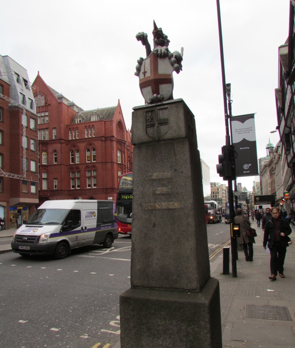
The City of London Boundary Marker
Passing on towards the Inns of Court and towards the city boundaries, just outside Chancery Lane underground station, is a street bollard marking the boundaries of the City of London: meaning, we were now leaving the City known to Roberts and the other men also being lead to the Gallows. Just passed the marker is Furnival Street which runs alongside the former site of Furnivals Inn and where Roberts had studied. We continued on toward St Giles in the Fields, stopping just outside the old public library of Holborn, no longer a library, simply another place available for rent. Here it was nice to stop and reflect on what surrounded us. The library once served what had been the densely populated area known as the St Giles’ Rookeries, now inhabited by businesses. A chance encounter with a young Asian man looking for an English-language centre, revealed that the area is not entirely devoid of places of learning: not public libraries nor Inns of Court but answering the need of today’s London.
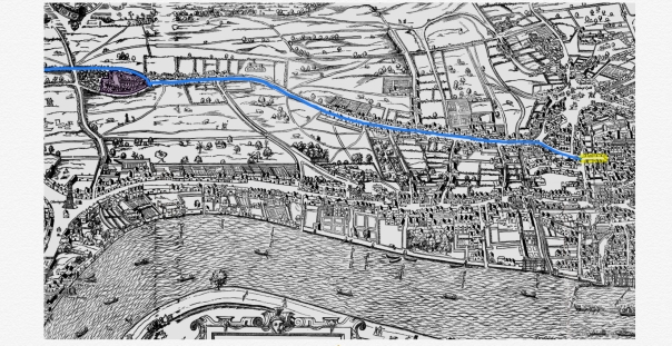
(Above is the route they would have taken, presented on the Agas map, Tyburn is not shown as it was too far out of London)
Our new stop was St Giles in the Fields, so called as there has been a church on the site probably from the 12thcentury onwards. Attached to a hospital serving sufferers of Leprosy, the hospital was later dissolved by Henry VIII. At the gates of St Giles in the Fields those, like John Roberts, condemned to death were offered the St Giles Bowl: a bowl of alefor those on their way to the gallows at Tyburn. We can suppose from this that Roberts and the others would have stopped here also. The modern church on the site is the largest parish church that Sir Christopher Wren designed, its interior is beautiful and contains this beautiful plaque at the altar of the prayer taken from the Gospel of St Matthew, the Our Father.
Next we attempted to follow the exact route on to Oxford Street, but were foiled by building works for the new Cross Rail development and so ducked through Soho Square taking a moment in St Patrick’s Church Soho. A peaceful moment in a bustling area, the church was built to serve the growing immigrant Irish Catholics in the 18thand 19thcentury. Below the Church are extensive catacombs which are well worth visiting if time permits.
Last leg of the Journey
Our small Pilgrimage then emerged on to Oxford street, where a different type of pilgrimage was taking place for those surrounding us. The pilgrimage of consumerism – pre-Christmas shopping – was in stark contrast to our journey and certainly to that of John Roberts. This last leg of the journey seemed the longest, and to Roberts perhaps also. Here the crowd would have grown on the main road to Oxford, as we approached Tyburn, at the time of Robert’s execution well out of the City and surrounded by fields and marshlands.
And so, on a small traffic island just beyond Marble Arch underground station, to a small plaque on the ground surrounded by three trees, evoking the triangle shaped gallows that once stood on the site. We stopped. The city continuing its business around us, unaware of what had occurred 408 years ago on that site. St John Roberts was the embodiment of subversion, attempting to carry out his work had run afoul of the religious intolerance and political fears of early Modern England. So, our journey to Tyburn had ended, as it had 408 years ago for John Roberts.
The Convent at Tyburn who pray daily for the 40 English Martyrs
Bibliography – all last checked and Accessed 12th December 2018
In doing research for my previous blog I came across Eleanor Marx, the youngest daughter of Karl. A political activist who earned her living as a translator, and has said to have been erased from history, overshadowed my her famous father. She was active professionally and politically at a time when women were not educated or independent. In keeping in mind her status in society and the ways she overcame this, I decided to follow one of her protest routes from the late 1800s, which started at the Marx Memorial Library, in Clerkenwell Green and ended in Trafalgar Square, as a way to honour her, as well as all the other women who walked.
Like her father, Eleanor fought for the rights of those who were not able to, and one way was organizing protests. For a woman to have organized and led a protest at the time would have been almost unheard of at the time, and although having Karl Marx as a father would explain her political motivation, I felt compelled by her story. The protest I choose to look into was in October 1889 she marched a procession of homeless people from Clerkenwell into the square, and although I could not find their exact route, I followed the route of the 2017 May Day rally organized by local trade unions. Through this walk I noticed some interesting parallels between what Eleanor was fighting against and what persists today.
Homelessness is a universal problem, which is particularly visible in London. Keeping in mind Eleanor’s procession of the homeless, I paid further attention to these people as I walked. As I got closer to Trafalgar Square there were more and more people on the streets, which represents a disappointing parallel between today and the late 19th century.
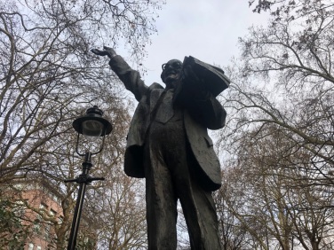
I also noticed the contradictory relationship London has with Britain’s imperial past. Throughout this walk were institutions and buildings honoring the British Empire near to celebrations of anti -imperialists, like Fenner Brockway. The British Empire has been the subject of countless discussions throughout history, and there are many who look back on the empire with a kind of fondness. Both Karl and Eleanor Marx were outspoken in their anti-imperialist stance, Karl Marx, known as the theorist behind Communism spent much of his time speaking about the inefficiencies of an Imperialist state, and his daughter followed. What I found interesting was that London seems to have accepted both ends of this debate. In the space of ten minutes one passes Red Lion Square, featuring a statue of Fenner Brockway, a socialist who was involved in the UK Labour party, as well as an anti-war and anti-imperial activist, followed by the preserved India House, a direct remnant of the colonial period.
Monument to Fenner Brockway, taken by authour
India House, taken by authour
The closer to Trafalgar Square the more apparent the legacy of Imperialism is. At the start of the walk, Clerkenwell Road is often looked at as London’s Little Italy. With St. Peter’s Italian church in the center of this, a remarkably beautiful building. Next to the church is shop L. Terroni & Sons, established by an Italian family in 1878, the persistence of these places serves as a testament to the culturally rich and diverse city London was and is. However going further into Westminster one cannot help but notice how it is not the cultural diversity which is celebrated, but British supremacy, ending in Traflagar Square with its monuments to British patriotism, in the form of Lions and the famous Lord Nelson’s column.
Little Italy, taken by authour
The third, and final reason I felt compelled to use Eleanor Marx as the base of this walk was the unusual nature of her political activism at a time when women could not be admitted to university. She translated the first English copy of Madame Bovary and was a very highly educated and successful translator and teacher, outside of her political work. One can also look at Eleanor through the realm of women who walked, as a common leader of protests. Although this was a generic protest route, I thought it was quite interesting to keep in mind her position in society as a politically motivated woman. I passed a number of monuments, statues and blue plaques and there is a distinct lack of women celebrated, I think the erasure of Eleanor from the historical record is a pertinent representation of the wiping away of women from history. However, along the walls of King’s College is a photo and little celebration of Virginia Woolf, which I thought was a nice thematic linking point, as she is the woman most commonly thought of on the topic of women who walked in London. Looking at the act of walking as a subversive activity may appear somewhat farfetched, however, when thinking about the confined, domesticated position held by women in the late 19th century, the act of walking politically or even outside of domestic activities would appear to be remarkable.
Taken by authour
Usually seen from the top deck of a bus, this is a route I have taken many times, but I have never experienced it like this. Which shows that when you look for it, the history and information reveals itself, just below the surface of the city. I was not expecting to find any direct references to Eleanor, however, there are so many indirect references to what she fought for and against. Thinking of Eleanor while walking gave me a new understanding of the route I have taken many times before. It made me think about the things that have changed, the role of women, and the legacy of the Empire, but also what has stayed the same, again the role of women, the legacy of Empire and the seemingly insolvable issue of homelessness. London is a fascinating city that straddles so many contradicting ideas, it is hard to truly make note of, but this is what makes London and its history so interesting, there can never be just one story being told.
Upon telling my South African grandmother that I’d be moving to London she lists the three favourite aspects of her visit ten years ago. The Central line, Kensington and a sunset. She can’t remember exactly where it was but considering how beautiful South Africa is, it must be pretty good. After some deducing, Primrose hill seems the likely location so for me it has become an excuse to wonder the streets of Camden. Today the sun sets at 15:53, my friends and I arrive at Camden Town station at 14:25 we have an hour and a half to discover.
I want to find something new so, we cross the road and take the first right off Camden High street; I know straight ahead will lead me to the markets and tell myself that’s not what I came for. The road is simply called Parkway/A4201 and after walking four minutes with little excitement the name seems fitting.
Nothing grabs me, until I am grabbed. A man, a Londoner I can tell from his bald head, the fact that he’s drinking slightly too early in the day and his accent when he says, “best pub in Camden!” and points to the sign saying, ‘Dublin Castle’. I have passed at least two pubs thus far and doubt this one would be of much interest either, but the man is charming, and my friend thinks she overheard someone mention that the pub is “really historical”.
We meet Catherine behind the bar who, when asked if she knew anything about the history of this pub, replies “are you kidding”.
The story goes that to quell ethnic tensions between the Camden railway navvies, four pubs were built to segregate the main nationalities. The Dublin Castle for the Irish, the Edinboro for the Scottish, the Pembroke for the Welsh and the Windsor for the English. But as Catherine says, the story of the Camden castles is largely a ‘legend’. Most telling by the fact that, contrary to the story, each pub was built at very different times; the Windsor castle opened in 1953, the Pembroke in 1860 and the Edinboro in 1839. The Dublin Castle is the oldest, dating back to the 1820s, and is by far the most interesting. It was in fact built for canal navvies who were mainly Irish, spoke little English and tended to live nomadic lives jumping from jobs. According to Anthony Burton, although these workers shaped Camden, not much is known about them- largely because they were feared, illiterate and of little interest to writers.[1] Now a legendary music venue, hosting the likes of pre-fame Blur, Madness and Amy Winehouse, it seems the pub has remained a refuge for outcasts.
We move on because the Dublin Castle holds enough character to fill a book. I leave wondering what a pub like this could tell us about the history of Camden culture but also of those men who left so little trace of themselves.
It is 14:46 when we step back onto the street. Walking five minutes up the road passing the Jewish museum and signs for the London Zoo, we stumble upon a statue and plaque labelled ‘Saint Pancras, Middlesex’. I find out that Camden had formerly been a civil parish known as borough of St Pancras until 1965. It seems the area has a history of unorthodoxy with the district being considered “the most freakish borough in London” in the 1950s.[2] A stone plaque affixed to the side of the fence honouring the Royal Commissioner Gerard James Noel for his role in acquiring Regents Park for the Crown reminds us how close we are to the Park. But the brightness of the sky shows it is only 3pm, too early, so we divert down a random street.
In aimless wander, following the canal north, we seem to have found ourselves at the markets we had hoped to avoid. Maybe led by tourist crowds or the smell of jerk chicken. Looking down onto the stalls lining the lock this is undeniably what Camden has always been for me.
Pushing through the Saturday crowd and into the indoor market I notice the railway above for the first time. The market had gradually grown from sixteen stalls around what was once an industrial hub based around the canals. The Railway above is part of many which in the 19th century eclipsed the canal trade but never succeeded in its ambition to become a fully-fledged trade route. The warehouses built in anticipation sat empty until the 1970s when Camden Lock markets became London’s first artisanal and antiques market.
For many, these markets have been where subculture comes to live, “it’s the closest thing cyber goths have to a Westfield” but looking at the overpriced incense, emoji pillows and used shirts I wonder if this is still the case. When did Camden become so expensive? Today Camden is considered the third most costly borough in London but up until the mid-20th century it was commonly an “unfashionable” district.[3] I don’t have space to answer this question, but the shifting stalls seems to be symptomatic of wider change in the area. Can Felix, who has worked at the markets for nearly thirty years, tell us anything about the changing demographic or class tensions?
The railway, the common theme in this walk, is what separates Primrose from Camden town. Far from the punk bars of Camden, this area has always been fashionable. Even in the mid-19th century the view atop the hill was famous with the hill becoming do crowded over Easter that “it seems one could walk upon the heads of those congregated there”. It had even been the location of choice for popular congregation before Hyde Park was adopted instead. Something interesting I discovered was that this iconic viewpoint could have been a cemetery as George Carden campaigned amidst 19th century London’s cemetery shortage for a London version of the Père Lachaise.
It is 13:46 when we reach the top of the hill, me and my legs saying this better be worth it. It’s not.
The overcast December skies leave the sun hidden, the wind forces us back down the hill scarcely after 4pm and to top it off my Grandma later tells me we got the location wrong. Turns out she meant Parliament Hill. I leave without my sunset but a slightly greater understanding of Camden.
Bibliography:
[1] Anthony Burton, The Canal Builders (UK: The History Press Ltd. 2005)
[2] David Mathieson, Radical London in the 1950s (UK: Amberley Publishing, 2016), p. 86.]
[3] Larkin Dunton, The World and its People (USA: Silver, Burdett, 1896), p. 29.


 Exit to Hyde Park gate.


 India House, taken by authour
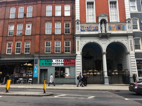

 Trafalgar Square, Taken by authour


